
One of Africa’s most striking geographical features is a giant tear across the earth’s surface visible even from space: the Great Rift Valley. Extending from the Middle East to Mozambique, the Rift Valley passes in a north-easterly to South-westerly direction right through Ethiopia, endowing the country with some spectacular sights range from hot, dry, and barren places to a string of beautiful lakes. This tremendous collapse of the earth’s surface occurred at the same time that the Arabia Peninsula, geologically a part of Africa. The Afar Depression is a plate tectonic triple junction where the spreading ridges that are forming the Red Sea and the Gulf of Aden emerge on land and meet the East African Rift. The Afar Depression is one of two places on Earth where a mid-ocean ridge can be studied on land, the other being Iceland. At present, the Afar is slowly being pulled apart at a rate of 1-2 cm per year. The floor of the Afar Depression is composed mostly of basaltic lava. The Afar Depression and Triple Junction also mark the location of a mantle plume, a great uprising of mantle that melts to yield basalt.
![]()
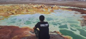
This place which used to be part of the Red Sea has kilometers of salt deposits’. In some places the slat deposit’s are about 3miles (5 KMS) thick. Below a salt lake is a substantial source of volcanic heat which causes hot water to rise through layers of salt and anhydrite deposits. Minerals get dissolved and are deposited, near the springs, and form shapes very much reminiscent (but smaller than) hornitos on basaltic lava flows. Sulphur, other minerals and possibly Thermopylae bacteria cause spectacular colors, Sundered from the rest of the continent. In Eastern Ethiopia, near the southern end of the Red Sea, an immense, more or less triangular depression descends far below sea level (at some points 120 meter below sea level). Known as the Danakil Depression, this extremely hot and dry area is actually a part of the Africa’s Great Rift Valley. In this seemingly inhospitable area there live the nomadic Afar people who number about 3 million. Their external borders are Eritrea, Djibouti, and Somalia. The region where these people live is also called Afar-one of the nine regions of Ethiopia. Its current capital is named Semera on the paved Awash – Assab highway. The Danakil, or Dallol, depression, which encompasses a good portion of the eastern part of the Tigray region, is one of the earth’s hottest and most inhospitable places, with many points more than 100 meters (328 feet) below sea level and noon-time temperatures soaring above 50 degree Celsius (122 degree Fahrenheit)
![]()
It is the site of a dry salt lake from which Ethiopians since time immemorial have obtained their amoles, or bars of salt, used both for consumption and, long ago, as a primitive sort of money. Minded by the Afar people for at least a millennium and a half, the salt is loaded on camels and taken to the highlands with long caravans, where it is still in considerable demand and fetches a good price.
![]()
A special place called “Erta Ale” (one of the most important active volcano in the world) is found in the Afar depression at 13.6°N, 40.67°E, with an altitude of 613 meter. It is a shield volcano, which has a base diameter of 140m diameter; 60 to 90m deep now has an active lava lake 60m wide and 100m long.
![]()
Long Description
Erta Ale Volcano
13.60 N, 40.67 E,
summit elevation 613 m
Shield Volcano
Erta Ale is a desert shield volcano. The name refers to a volcano as well as a mountain range. The base of the volcano is 75 m below sea level in the desert. Erta Ale volcano has an active lava lake which may have been present for as long as 80 years.
![]()
Records of the volcano date to the 1600’s, but a lava lake was only identified in 1960’s. The Afar language calls it “smoking mountain” which indicates it has been active for a long time. The Afar region is the only place on earth where a tectonic triple junction is located above sea level (Red Sea, Gulf of Aden, and African Rift Valley).
![]()
Erta Ale volcano can be considered equivalent to submarine spreading ridges. The Erta Ale Range is 95 km long and 50 km wide. Erta Ale volcano has feature similar to the Hawaiian volcanoes of Kilauea and Mauna Loa. The caldera is 1.6 km x 0.7 km in diameter and two pit craters are often filled by lava lakes.
![]()
The summit of Erta Ale is occupied by an ellipse-shaped sink elongated NNW-SSE (1600 X 700 m). Its northern end contains two pit-craters. The sink probably resulted from three collapse-structures. The northern one corresponds to the main pit crater. The southern and central pits could either corresponds to an ancient pit, or to a simple collapse structure. The main pit-crater, 200 m deep and 350 m across, is sub circular and three storied. The smaller southern pit is 65 m wide and about 100 m deep.
![]()
A large collapse structure is located South of Erta Ale volcano. It consist of an elliptic sink-hole (3.1 x 1.8 km).
2013 Eruptions
Erta Ale remains active in January 2013 with satellite images showing hotspots over the volcano.
![]()
Dallol, Ethiopia: The Hottest Place on Earth
How Hot is Dallol, Ethiopia?
Dallol, Ethiopia is the hottest place on Earth based on year-round averages, which is to say that if you average the temperature of every place on Earth for one year, Dallol’s average will be the highest. There are places in the world that are hotter at given moments but Dallol is the hottest on average.
Another thing that makes Dallol so hot, its high humidity (around 60 percent) and the noxious fumes that rise out of its Hades-looking sulfur pools notwithstanding, is the fact that it doesn’t cool off at night. While many of the world’s hot spots are located in deserts, where temperature extremes between day and night are just as dramatic as the extreme temperatures experienced during either, Dallol has an average low temperature of 87 degrees Fahrenheit, which is hotter than many places on Earth ever get